Join the Conversation

Join the Conversation.
I invite your comments, suggestions, and additional information about any topic mentioned.
Showing posts with label Marietta earthworks. Show all posts

Friday, August 11, 2017

John Quincy Adams visits Marietta

Shortly before 2:00 pm on November 15, 1843, the bell tolled at the First Congregational ("Two Horned") Church in Marietta. Crowds rushed towards the church, others to the Ohio River landing. They were eager to see former President John Quincy Adams who would arrive by riverboat and speak at the church.

"JQA" (Adams referred to himself this way) was stopping on his way to Pittsburgh from Cincinnati. He  had spoken at the cornerstone laying of the Cincinnati Observatory on November 10. This was reported as JQA's last public speech, though he spoke in Marietta a few days later.

John Quincy Adams Portrait -copy of 1843 Philip Haas daguerreotype viewed at 
https://commons.wikimedia.org/
CLICK TO ENLARGE

Citizens of Marietta had invited JQA to visit after hearing that he would be speaking in Cincinnati. He accepted the invitation, at least in part because he knew of Marietta's history and settlers, many from his native Massachusetts. 

There was no time set for his arrival in Marietta. The tolling of the church bell would be the signal. Observers closely monitored river traffic, looking for the steamboat Ben Franklin. JQA arrived around 2:00 pm. His journal reports that he received "...demonstrations of welcome - a great crowd of people, guns fired, bells rung, and a procession to the...church."

Steamer Ben Franklin docked at Cincinnati
Image from Northern Kentucky Views at http://www.nkyviews.com/carroll/carroll741.htm
CLICK TO ENLARGE

He was escorted to the church by civic leader Nahum Ward. There was heavy rain during his visit, though JQA does not mention that in his journal. It did not seem to dampen the enthusiasm for the former president.

The church was crowded with people eager to see the former president.  Judge William Rufus Putnam, son of Marietta founder Rufus Putnam, gave a welcoming speech and introduced the former President.
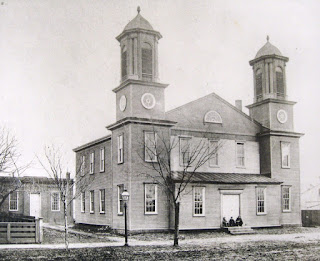
First Congregational Church
Church image from mariettafirstchurch.org website
CLICK TO ENLARGE

JQA spoke without notes for about half an hour, praising the founders of Marietta, including Rufus Putnam. Those present were surprised by his detailed knowledge about the original settlers, their families, and their experiences in early Marietta. He praised Commodore Whipple, who "fired the first gun on the sea at the British, in the opening of the Revolutionary War." He mentioned many familiar names of original settlers, such as Tupper, Meigs, Varnum, Parsons, Devol, Green, Fearing, and more.

JQA explained that his interest in Marietta began when he visited Manasseh Cutler at Ipswich MA in 1788, shortly after Cutler had returned from Marietta. He said, "...from the time of that conversation I had taken a deep interest in the whole West, and watched its progress, step by step, to its present great and flourishing condition." 

He may have read about the early Marietta area residents from their letters published in Massachusetts newspapers. Life on the western frontier was a curiosity to easterners.  Whether he actually recalled details from 50 years earlier or refreshed his knowledge before the Marietta visit, he had a firm command of the topic as he spoke. 

After the speech, he greeted citizens at the church. Many ancestors of the original settlers whom JQA had referred to were present. One observer noted: "It was a singularly impressive sight to have the children and grandchildren of the very men Mr. Adams had been speaking of, come up and shake his hand." 

George Dana, a descendant of Captain William Dana, brought his young son, John Quincy Dana, to meet the former president. Dana said, "Here is my youngest son, whom I have named to show my esteem for you." JQA placed his hand on the boy's head and pronounced "God bless you my son."

After leaving the church, he toured the Marietta Earthworks, the extensive system of Hopewell and Adena mounds, embankments, and pathways. Marietta's founders wisely took steps to protect these structures. JQA wrote about these in his journal entry of the Marietta visit, recording detailed measurements of one mound and referring to an article about them by Manasseh Cutler.

He then returned to the boat. Marietta leaders Ephraim Cutler, Caleb Emerson, and Joseph Barker accompanied JQA to Pittsburgh. Cutler observed that JQA "conversed with great ease and freedom on the many topics introduced, 'opening the rich store-house of his mind, and pouring forth its well assorted treasures.' " 

Ephraim Cutler's journal mentions two topics that he discussed with JQA on the trip. He told the former president that the nation was indebted to his father, John Adams, and to John Jay for their efforts in securing all lands west to the Mississippi River for the United States in the Treaty of Paris. Without this land, the Northwest Territory - which included Marietta and later Ohio and five other states - could not have been created. Tears welled up in the the former president's eyes, and his voice hesitated. He expressed gratitude that Cutler had remembered his "beloved father."

Cutler also mentioned the issue of slavery. The former president was a lifelong opponent of slavery, often speaking out on the matter. Just prior to this trip, JQA recorded in his journal: "Before my lamp is burnt out, I am desirous that my opinions concerning the great movement throughout the civilized world for the abolition of slavery should be explicitly avowed and declared."

Ephraim Cutler told him of the state constitutional convention in 1802 which voted to exclude slavery in Ohio. Cutler was a delegate and fought hard at the convention for a total prohibition of slavery. An alternate provision - authored by Thomas Jefferson -  would have allowed a limited form of slavery. JQA emphatically responded, "Slavery must and will soon have an end." He presciently stated that allowing slavery to continue would lead to national conflict. 

Other observations about John Quincy Adams and his visit to Ohio:
  • JQA was an introvert who may have suffered from depression. His public demeanor was austere. However, Marietta treated him like a rock star and "(cheered) him most heartily."
  • His trip to Ohio was a lengthy one, beginning on October 25 and lasting over a month. It was tiring. His journal records meetings, receptions, tours, and visits each day. He was ill with a bronchial infection for several days but did not miss any events. 
  • Travel modes on the trip included rail car, lake steamer, canal boat, coach, and river steamer. 
  • He delivered lengthy speeches, as was the custom at the time. His plan for the Cincinnati Observatory speech was bold: "I want to compress the history of astronomy into a discourse of three hours delivery. My task is turn this transient gust of enthusiasm for the science of astronomy at Cincinnati into a permanent and persevering national pursuit." He fretted about being pressed for time to write this speech. 
  • JQA was a lawyer, statesman, and politician. He served as ambassador to several countries, US Senator, Secretary of State under President Monroe before being elected president in 1825.  
  • After leaving office as president in 1829, he served in the US House of Representatives until his death in 1848. 
  • He married Louisa Catherine Johnson in London, the only president to have a foreign-born First Lady until President Trump. 
  • He liked to skinny-dip in the Potomac River
  • First president to be photographed by Phillip Haas in 1843. The finished image was a daguerreotype; a digitized copy appears above in this blog post.
  • I1779 at age 12, JQA began a diary which he kept until just before he died in 1848. It comprised an unprecedented 14,000 pages in 51 volumes. It is digitized and be viewed in his original handwriting or in transcribed and searchable format. 

Thursday, February 18, 2016

Marietta Earthworks

If you have been in Mound Cemetery or walked around at Camp Tupper Park in Marietta, Ohio, you have seen a major feature of the Marietta Earthworks. They are remnants of the vast Hopewell civilization which flourished from 100 BC to 500 AD in the eastern U.S. These impressive structures were abandoned and sat dormant for centuries. The earthworks were brought back to life at Marietta in the late 1780's - this time as objects of curiosity by settlers from the eastern U.S.

The Earthworks was a system of mounds, embankments, and open paths which occupied a major portion of the original town. Below is a map of the earthworks as drawn in the 1830's. You'll notice a large square, a smaller square, the circular Conus mound, and the graded pathway to the Muskingum River. 

CLICK TO ENLARGE
Map of Marietta Earthworks from Moundbuilder.blogspot.com; originally credited to Charles Whittlesey in Squire and Davis, Ancient Monuments of the Mississippi Valley, but which researcher William F. Romain believes was done by Samuel R. Curtis, an engineer with the State of Ohio at the time, about 1837.


Marietta earthworks were the first in America to be documented
The earthworks were, except for a sketch of earthworks at Circleville in 1772, the first to be documented in America. That they were even noticed is remarkable considering the thick forest that blanketed the entire area.

Joseph Buell, stationed at Fort Harmar, mentions them in his journal, on February 1, 1787:..."this day I took a walk with Serg't Shaumburgh, Strong Orcatt, & Munsell to view the curiosities of the mountains which afforded us great Satisfaction...." The term "curiosities" reflected early reactions at the time to the earthworks - a blend of awe, scientific enigma, and UFO-like mystery. 

CLICK TO ENLARGE
Image of Heart's drawing, at Christoper Busta-Peck Flickr website: https://www.flickr.com/photos/cbustapeck/19577659676/in/photolist-vQ1C9u-bXbbhe-dT6Zg7-cx5e8S


The first detailed drawing, circa 1786, (see above) is attributed to Captain Jonathan Heart, also a soldier at Fort Harmar. General Josiah Harmar, the fort's namesake, wrote to General Thomas Mifflin of Philadelphia: "Be pleased to view the inclosed plan of the remains of some ancient works on the Muskingum, taken by a captain of mine (Heart), with his explanations. Various are the conjectures concerning these fortifications. From their regularity I conceive them to be the works of some civilized people. Who they were I know not. Certain it is, the present race of savages (American Indians) are strangers to anything of the kind." 

Heart's drawing and notes generated considerable scholarly interest in the east. General Samuel Parsons had toured the Ohio Valley, and had studied the Grave Creek Mound (at Moundsville, WV) and those at Marietta. In May 1786 Parsons sent his mound data (including Heart's drawing and notes) to Ezra Stiles of Yale University. Stiles forwarded the Marietta earthworks data to Thomas Jefferson and to Benjamin Franklin for their opinions on the their origin. In October of 1786, Parsons sent similar information to President Joseph Willard of Harvard University.

Noah Webster wrote a letter to Stiles supporting a theory, first mentioned by Benjamin Franklin, that the Marietta earthworks were built by Spanish explorer DeSoto during his 1539 expedition. Heart's map appeared in the May, 1787 edition of Columbian Magazine. To recap: Harvard, Yale, Thomas Jefferson, Benjamin Franklin, Noah Webster and others expressed genuine interest in curious piles of earth in Marietta, Ohio. Pretty impressive.


Image of Columbia Magazine May 1787 issue which lists Captain Jonathan Heart's drawing in the index. It appears as Roman Numeral VII in the list. This image is from Archive.org at


Ohio Company was proactive in research and preservation                

The Ohio Company of Associates were the organizers of the settlement of Marietta. Their leaders surveyed the earthworks, recognized their historical significance, and prudently took action to protect them. Rufus Putnam, Superintendent of the Ohio Company, conducted a detailed survey of the earthworks. Images of his work are below.

CLICK TO ENLARGE
Rufus Putnam's drawings of the mounds and earthworks and notes below, from
The Memoirs of Rufus Putnam and Certain Official Papers and Correspondence

CLICK TO ENLARGE
References to notes (on right side of the image above) on Rufus Putnam's drawing 


Manasseh Cutler, a member of the Ohio Company and an ordained minister with scientific training, also closely observed the mounds. He estimated their age by counting tree rings on some of the largest trees growing on them. The largest tree was 462 years old. There were other large stumps visible, indicating preceding growth of a similar length of time. From this he estimated that the mounds were at least 1,000 years old. This finding allowed him to refute Noah Webster's DeSoto theory.

The earthworks were considered part of the town. They were given Latin names by the Ohio Company: Quadranaou for the largest mound at Camp Tupper, Capitolium for the one at the Public library location, Conus for the Mound Cemetery mound, and Sacra Via for the parkway leading from Third Street to the Muskingum River.

The groupings of earthworks (refer to the Whittlesey drawing above) also had informal titles. The largest square enclosure was "The Town," the smaller square "The Fort," the cemetery mound was the "Great Mound and Ditch," and Sacra Via was the "Covered Way." 

Preservation efforts - success and failure
The Quadranaou, Capitolium, Conus mounds and Sacra Via parkway were set aside as protected common areas by the Ohio Company: "Resolved, That Colonel Battelle, Colonel Crary, and Major Sergeant be a committee to lease the public squares (to Samuel H. Parsons, Rufus Putnam, and Griffin Green, esqs.), the ones on which the great mound (Conus), the Quadranaou, and Capitolium,....The committee are to point out the mode of improvement for (beautification), and in what manner the ancient works shall be preserved...."

Those earthworks were thus leased to individuals for safekeeping. Sacra Via was under the informal supervision of Rufus Putnam. This system was continued over time, but there were serious lapses. Conus was set aside as a cemetery, but it was not fenced for decades. The mound suffered serious erosion from sheep and people climbing the mound - compounded by water runoff. The mound was eventually repaired and fenced.

In 1820, Quadranaou was being leased to D. Hartshorn who transferred control to Rev. Joseph Willard. Incredibly, Willard started plowing down the mound! Fortunately, there was a public outcry. A legal wrangle ensued, but courts sided with the city's control of the property. Willard was removed and citizens worked to restore the damage. 

The special case of Sacra Via
Sacra Via (Latin for Sacred Way) was the excavated graded pathway from Quadranaou to the Muskingum River. It was to be protected..."never to be disturbed or defaced, as common ground, not to be enclosed." But the large boundary walls were destroyed in a regrettable lapse in governance. A city council member, who was a brickmaker, talked the city council into selling the earthen walls to him for bricks. The bricks were reportedly used in the construction of the Unitarian Church.

The original Sacra Via earthwork was a dominant structure, quite different from the level park of today. Parallel earthen walls bounded the Sacra Via parkway for a  length of 680 feet. The rounded walls were nearly 40 feet wide and 8 ft high. The interior pathway descended uniformly toward the river, and was excavated below the surrounding terrain. The pathway was 8 ft below grade at the upper end but steepened to 18-20 ft near the river. 

The effect was dramatic. Someone standing in the lower pathway would have been looking 20+ ft upward to see the top of sidewalls. Some theorized that the below grade section was for a defensive military feature to allow an undetected avenue of escape to the river. A Charles Sullivan charcoal drawing of the scene (below) conveys some of the visual effect. We know boundary walls were used for bricks, but what happened to the graded excavation? It's barely discernible now.       

From Ohio History Connection Archaeology Blog: "It's that most wonderful time of the year", Dec 13, 2010
Americanantiquarian.org.: Ancient Works, Marietta, Ohio. Based on a painting, this lithograph shows the (Sacra Via) elevated plain with elaborately constructed fortifications. “Ancient Works, Marietta, Ohio,” in Ephraim G. Squier and Edwin H. Davis, Ancient Monuments of the Mississippi Valley(Washington: Smithsonian Institution, 1848), pl. 26, p. 73.

The challenge of protecting our heritage
Unfortunately, much of the original Marietta Earthworks network of extensive boundary walls and smaller mounds has been destroyed over time. These were on private property, not in protected areas. 

Fortunately, enough of the major features remain for us to realize their importance, uniqueness, and cultural value. But there will always be preservation challenges - from wear, erosion, and land use changes over time. It is imperative that we remain faithful stewards in protecting them and in pressing for additional research about them.

https://acrobat.adobe.com/id/urn:aaid:sc:VA6C2:78a4a6af-cf99-4bfa-97df-3c825f635d25


Sources:

Ancient Ohio Trails website: ancientohiotrails.org, "Marietta" page views
Barnhart, Terry A., American Antiquities, Revisiting the Origins of American Archaeology, University of Nebraska Board of Regents, 2015, pages 96-115, viewed at Google Books-https://books.google.com/
Butterfield, Willshire, Consul, Journal of Capt Jonathan Heartetc., Albany, NY, Joseph Munsell's Sons, 1885, pages x-xiv.                                                                                         Foster, J. W., Prehistoric Races of the United States of America, Chicago, S. J. Griggs and Company, 1874, pages 128-30, 351
Lepper, Bradley T, Ohio Archaeology, Wilmington OH, Orange Frazer Press, 2005, pages 164-68, 241
Lynott, Mark J., Hopewell Ceremonial Landscapes of Ohio, Havertown, PA, Oxbow Books, 2014
Maclean, J. P., "Ancient Works at Marietta," Ohio Archaeological and Historical Publications, Volume XXII, Pages 37-66, viewed at http://www.ohio.edu/people/sandford/Articles/AncientWorksatMarietta.html.                     
The Memoirs of Rufus Putnam and Certain Official Papers and Correspondence, The National Society of the Colonial Dames of America in Ohio, edited and compiled by Rowena Buell, Boston and New York, Houghton Mifflin and Company, 1903.
"Mound Cemetery (Marietta, Ohio)," Wikiwand.com, viewed at http://www.wikiwand.com/en/Mound_Cemetery_(Marietta,_Ohio)
Sandford, Chris, website "Marietta Earthworks" at http://www.ohio.edu/people/sandford
Williams, H. Z., History of Washington County, H. Z. Williams & Bro., 1881, Chapter XXXVI, Pages 439-443 excerpt, viewed at a website created by Chris Sandford http://www.ohio.edu/people/sandford/Articles/MariettaWilliams.html
Wikiwand.com


Saturday, January 30, 2016

Winter Solstice

I had learned just recently that certain of the Marietta (Ohio) Hopewell earthworks were built to align with sunset on the winter solstice. They formed a 2,000 year old astronomical observatory system. William F. Romain documented this with measurements in his book Mysteries of the Hopewell. The book displays a cover photo - taken by the author on December 21, 1996 - of the winter solstice sunset at Sacra Via in Marietta:


December 21, 2015, the usual date for the winter solstice, was overcast and cold. It was definitely not sunset viewing weather. Luckily for us the winter solstice for 2015 was on December 22, a sunny and clear day. I decided at the last moment to view this event for myself.

My grandson Connor was visiting with us. The two of us drove to Camp Tupper, the park where the Quadranaou mound is located. I was surprised to find a sizable group of people standing atop the flat mound. They were clustered along the axis line on the mound where the setting sun at that moment was, just as advertised, perfectly aligned. I was transfixed. It was awesome, in the true sense of that word. 


Photo by author on December 22, 2015 on Quadranaou mound. The group in the center foreground is roughly lined up on the axis pointing to the setting sun.

Folks were watching, taking pictures, gesturing, and chatting with each other. Many were talking with Wesley Clarke, a local archaeologist, who had presented a program and was now answering questions. He handed out a copy of the Charles Whittlesey map of the Marietta earthworks published in 1837, a portion of which is shown below.


Above:Photo by author of map distributed by archaeologist Wesley Clarke on December 22, 2015. The map is based on an original drawing (see image below) published in 1837 commonly attributed to Charles Whittlesey, but which author Romain believes was done by Samuel R. Curtis, a civil engineer for the State of Ohio at the time.
Below: full version of the drawing, from Squire and Davis, Ancient Monuments of the Mississippi Valley.


The Marietta Earthworks is a group of mounds, embankments, and open paths which occupied a major portion of the original town. There were two large structure groupings (which appear as squares in the bottom drawing) and the graded pathway (Sacra Via) to the Muskingum River. There were also earthworks at other locations in the Muskingum River valley. They were part of extensive earthworks throughout the eastern U.S. credited to the Hopewell civilization which flourished from 100 BC to 500 AD.

Look at the top drawing above to visualize the sunset alignment. Find the rectangular mound with an extension on each side - marked A. That is the Quadranaou mound in Camp Tupper park. The line connecting the two side ramps pointing towards the river is the axis to the sunset. Find the mound marked B, to the right of A. That is the Capitolium mound where the public library now stands. It too lines up with the sun and so also does the Sacra Via parkway connecting the large square to the river - labeled "Graded Way" in the drawing. 

William F. Romain's solstice sunset calculations are meticulous and fascinating. He compares expected calculations of the sunset direction - based on the latitude and estimated age of the mounds - to the current orientation of the mounds today. The calculation is adjusted for the height of the opposite ridge (Harmar Hill) where the sun "sets" over the hill.

Here is his narrative: "...from Aveni's tables* we find that given a date of A.D. 250, 39 degrees 20 minutes north latitude, lower limb tangency, and a 7.0 degree horizon elevation, the winter solstice sun would have set at an azimuth of 231.3463. Recall that the azimuth of the Quad Mound's minor axis is 231.5. Accordingly, the Quad Mound is aligned to the winter solstice sunset to within two-tenths of one degree (231.5 - 231.3463 = .153 degree." Pretty, close, eh? There are similar computations for the Capitolium Mound and Sacra Via.

*Computerized calculations generated by Dr. Anthony F. Aveni, Colgate University physics and astronomy professor.

John E. Hancock of the University of Cincinnati has studied many Hopewell earthwork structures. He notes that: "Studies of the (Hopewell) earthworks indicate that the builders had a remarkable understanding of mathematics and geometry, a deep knowledge of astronomy, a common unit of measure, and reliable methods of surveying. It also indicates that the Hopewell people did not lay out their earthworks in a haphazard manner. They built them according to a predetermined plan that incorporated the cyclical movements of the sun, moon, and perhaps the planets and stars as well."

The Marietta earthworks are in a select group of structures built by civilizations around the world that marked solstice solar and lunar events. Newark Earthworks in Ohio is one excellent example among Hopewell structures. There are numerous examples from other civilizations, including Stonehenge and the Glastonbury Tor in England, the pyramids of Egypt, the Goseck Circle in Germany, Chichen Itza in Mexico, the four-handed Moai statue on Easter Island, Newgrange in Ireland, the Temple of Karnak in Egypt, and many others.

The amazing thing to me is that so many different civilizations noticed the solstice/equinox cycles, considered them important, and created structures to observe them. All of this occurred independently, since many of these cultures presumably did not interact with each other.

Much of Marietta's earthworks network has been destroyed over the years. We are fortunate that some major features have been preserved. They remind us today of our unique heritage, hiding in plain sight and often taken for granted, shared with ancient cultures around the world.


Sources:
Ancient Ohio Trails website: ancientohiotrails.org, "Marietta" page views
Lepper, Bradley T, Ohio Archaeology, Wilmington OH, Orange Frazer Press, 2005,
Lynott, Mark J., Hopewell Ceremonial Landscapes of Ohio, Havertown, PA, Oxbow Books, 2014
Maclean, J. P., "Ancient Works at Marietta," Ohio Archaeological and Historical Publications, Volume XXII, Pages 37-66, viewed at http://www.ohio.edu/people/sandford/Articles/AncientWorksatMarietta.html
Ohio History Connection Archaeology Blog: "It's that most wonderful time of the year", Dec 13, 2010
Pritchard, Angela and Belsebuub, Path of the Spiritual Sun, on line extract at Belsebuub.com: "Ancient Sacred Sites Aligned to the Winter Solstice," copyright BelsebuubDotCom, 2012
Sandford, Chris, website "Marietta Earthworks" at http://www.ohio.edu/people/sandford
Williams, H. Z., History of Washington County, H. Z. Williams & Bro., 1881, Chapter XXXVI, Pages 439-443 excerpt, viewed at a website created by Chris Sandford http://www.ohio.edu/people/sandford/Articles/MariettaWilliams.html